Geospatial data to guide strategy, plan investments, and manage the supply chain.
Crop Type Identification
Identify the crops growing in key regions.
Boundaries Detection
Accurately measure cultivated areas and field boundaries for each Area of Interest.
Coming soon
Yield Prediction
Forecast expected yields to plan procurement and mitigate risks.
Coming soon
Harvest Event Detection
Anticipate harvest windows and optimize production and logistics planning.
Coming soon
Identification of Fields with High Disease Risk
Identify high-risk areas and protect the quality of your supply chain.
Coming soon
Planting Trends Prediction
Uncover early planting trends to guide sales and resource allocation.
With xFarm Crop Intelligence,Artificial Intelligence and satellite data are transformed into reliable, actionable territorial insights. It enables precise identification of crops within Areas of Interest, measurement of cultivated surfaces, yield estimation, and continuous monitoring of seasonal trends in strategic areas. This provides concrete support for planning sales, investments, and procurement based on objective data — reducing uncertainty and improving decision quality.
xFarm Crop Intelligence provides practical tools to monitor cultivated areas across supply basins and support decision-making throughout the entire supply chain.
Monitor basins in real time
Plan deliveries and logistics in advance
Identify critical issues and activate alternative supplies
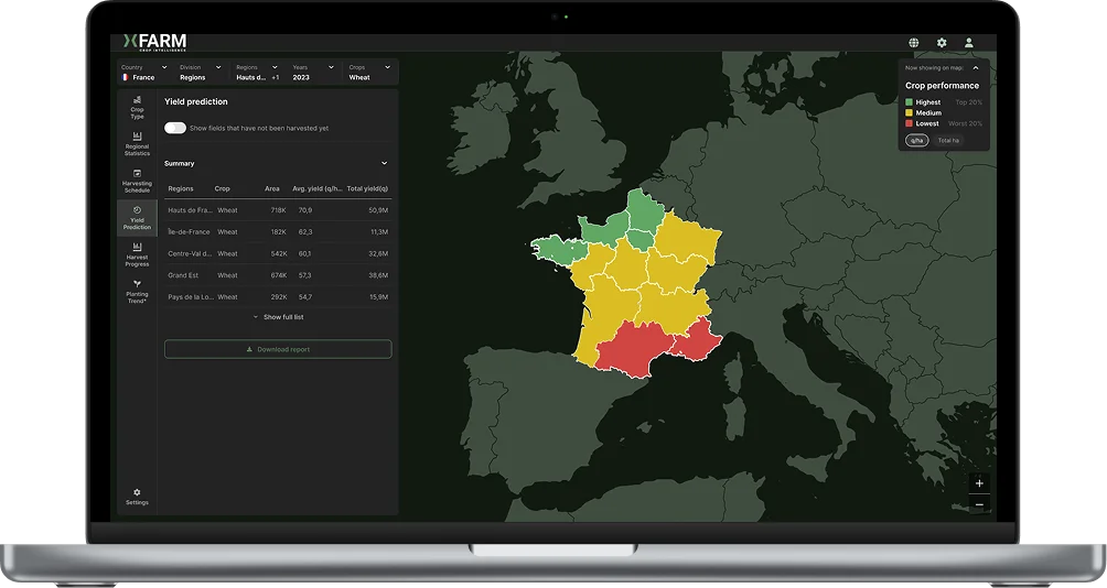
Yield Prediction
Coming soon
The functionality Yield Prediction feature will allow you to estimate the expected yield by crop and geographic area, helping you anticipate product availability and reduce the risk of shortages. You will be able to plan purchases in advance, diversify sourcing, and secure your supply chain before price and logistics peaks.
Harvest Event Detection
Coming soon
With Harvest Event Detection, you will be able to automatically identify harvesting windows in different areas and estimate the expected volumes for delivery. This provides a decisive advantage for improving production, warehouse, and transport planning.
Identification of Fields with High Disease Risk
Coming soon
Identification of Fields with High Disease Risk feature will help detect the most vulnerable areas by comparing historical and in-season data. This enables you to focus investments on the most promising basins and activate alternative solutions in case of critical issues.
xFarm Crop Intelligence provides an objective foundation to define sales strategies, targets, and commercial coverage based on actually cultivated hectares rather than estimates.
Set targets on verified hectares
Plan sales, KPIs, and resources based on objective data
Track seasonal trends and anticipate market needs
Crop Type Identification and Boundaries Detection, you gain a clear and up-to-date view of the crops in your areas of interest, identifying types and cultivated surfaces for each area. This enables to set more accurate production and sales goals, redesign commercial territories, and targeted guidance for your network activities.
Planting Trends Prediction
Coming soon
The functionality Planting Trends Prediction feature will provide an early reading of seasonal trends, allowing you to understand months in advance which crops to focus on, where to strengthen sell-in, and how to balance stock, budgets, and commercial resources based on market signals.

.png)


.svg)